Interested in landscape photography and hiking/trekkings? You're in the right place! I'm Melissa and this blog is all about photography and stories about being out in nature - whether that be on foot, on snowshoes or in a packraft.
Arctic autumn in the mountains of Sarek national park
When I walked the northern half of the Kungsleden, five years ago, I crossed the eastern border of Sarek national park and was immediately drawn in by the views towards this place. Back then, the thought of a mountainous area without huts or offical trails was still quite scary. Two years ago, I hiked along the west side of Sarek, looking from the gentle rolling tundra of Padjelanta with its many lakes towards the sharp, snowy peaks. I then vowed to explore those mountains one day. This year I wasn't intimidated anymore by the thought of river crossings or snow or off-trail hiking or sheer solitude. I was ready for Sarek.
River delta in the heart of Sarek
After some careful planning, early September I took a night bus north to Sweden, caught a train to Stockholm and then stepped onto the beloved night train towards the arctic circle. I shared a sleep compartment with four other hikers, most with equally large backpacks. Several of them had to get up very early to catch the bus from Murjek to Kvikkjokk, so we chatted about the areas we would go to for a while before dozing off early. I hopped off in Gällivare instead to then start my own hiking trip from the dam of Suorva. This trip report will be more detailed than what I usually write, so hikers will have one more information source about this famous yet relatively mysterious national park. (There isn't even an English guidebook).
Climb from Suorva, looking back towards the dam.
About Sarek Sarek is situated far into Sápmi, in the northwest of Sweden. It's the largest of the national parks and nature reserves that together form the Unesco world heritage area called Laponia, assigned to protect both nature and the partly nomadic lifestyle of traditional Sami reindeer herding. (Another interpretation I've heard is "we can do nothing profitable with those areas, so let the reindeer keepers have them". The border of the national park was actually moved in order to allow for the building of a dam.) Sarek is seperated from the Norse mountains only by the Padjelanta plateau. Within its borders lie steep mountains, small glaciers, marshes, lakes, birch forests and river deltas. Sarek is however botanically less diverse than for example Padjelanta. Valleys both wide and narrow are part of reindeer migration routes and make cross-crossing the area on foot fairly easy, more so because rivers judged to be unfordable are bridged. Rather famously, Sarek doesn't have STF mountain huts and the offical trails Kungsleden and Padjelantaleden only skirt the edges. To call this area the 'last wilderness of europe' is ridiculous and even somewhat offensive, however. Even leaving aside questions about what a wilderness even is and the problems that come with that catagorization, Sarek literally has been home to Sami people and their anscestors for thousands of years, leaving traces both visible and invisible. It's a cultural landscape with its own human history. Most of that human touch just happens to be fairly light (something to be admired!). Also, it is hardly the only place in europe without hiking facilities or marked trails. A lot of people head to Sarek each summer and things like simple shelters, reindeer fences and unmarked trails are scattered around the area. I've felt farther away from civilisation in other places.
One of the cabins in Sarek. Most are locked.
That said, there's no phone reception or accommodation or food supply opportunity within Sarek, so you will have to carry everything and rely on yourself for days on end. Weather can be unpredictable and temperatures regulary drop below freezing even in summer. During my hike I noticed that the mountain tops, sometimes over 2000 meter in height, have a tendency to grab onto clouds, which is why the amount of percipation here is higher than the Swedish average. Some hikers don't get to see the mountains at all because they stayed enveloped in low cloud all the time (something I experienced for days near the end of my trip). Sometimes people have to be flown out because they become stuck by high water levels. Hikers to Sarek should have reliable gear, an emergency communication device, be experienced in off-trail walking and navigation, and know how to safely cross rivers and snow fields. If you are ready and prepared, though, Sarek is a gorgeous and not too challenging area to explore on foot. I loved hiking directly beneath its sheer mountains tops and glaciers.
I came across this beautiful maquette of Sarek in the Sámi museum in Jokkmokk. I drawed in my route, starting from Suorva in the upper right corner, and ending in Kvikkjokk in the bottom. Without the side trips about 130km.
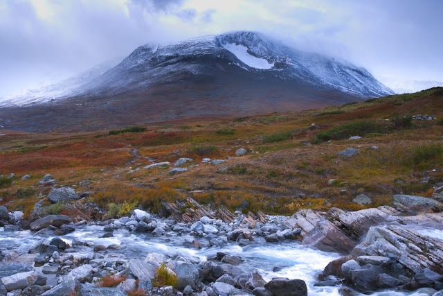
Right into the heart of Sarek: Suorva to Liehtjitjávrre I was warned, both by the guidebook and several trip reports, that the first climb of my hike would be streneous. One hiker went even so far as to call it a 'hell'. I envisioned wrestling through trees and bushes. Clambering on slippery boulders. Sinking knee-deep in bog. But, in all honesty, it was not hard at all. (Take my opinion with a grain of salt, however, for after my trip to the Nuuk fjords of Greenland last year I might never call anything difficult again). The bus dropped me off at Suorva on a delightful sunny late afternoon. I walked a few relaxed km's on the winding road right below the dam - there's a open door expecially for hikers in the middle of the road gate. I then followed the lake shore for a while, below the reindeer fences which obscure the old start of the route, before I came across a larger stream marked on the map. My guidebook told me to cross the stream here and start climbing later. I however spotted a vague trail on the right side of the stream and decided to follow that, because it would make finding the real trail easier. And that turned out to be a good decision. It was fairly slow climbing up through the birch forest, often wet and muddy, but nowhere difficult or really steep. And then, sooner than expected, I stumbled upon a clear trail that headed in the right direction.
Road beneath the dam. The door in the middle of this gate is open.
Among the colorful birch trees, above the artificial lake
After hiking about two hours total I found an established camping spot and pitched my tent, enjoying a lovely sunset amid the full autumn colors. The first night in a tent always feels a little odd but tired as I was, I slept very well. The next morning it was half cloudy, half sunny. After ten minutes of walking I already cleared the tree line. The views back over the lake were really nice (even artificial lakes can be beautiful), and before me out of the clouds emerged the perfectly conical mountain Slugga, showing me which valley I would head into. I sometimes lost the trail but that didn't slow me down much. The first serious river crossing on my way was the Njavvejagasj, which turned out to be the most difficult one of the entire trek. Twice I had to turn around because the water was fast flowing and deeper than I anticipated. But a bit lower down I found a shallower part. With high water levels, it's clear this river can become a major obstacle. After the crossing, there were some rocky parts and some parts through knee high shrubbery and bog that you can't get around. But, again, nothing too hard. I pitched my tent at the beginning of Liehtjitjávrre (it's all Sámi names here!), with a beautiful view towards the Ähpár glaciers that form the source of this lake, just before it started to rain.
Epic view towards two glaciers.
Along the glacial lakes to gorgeous Skarja in snow and sunshine The next morning, I woke early to the noise of a snow storm. My tent held up well and I was comfy in my -10C down sleeping bag, so I dozed off for a while longer before packing up and leaving. The next two days were exhilerating; sometimes I walked in sunshine, sometimes I was enveloped in whirrling snow, and between the snow showers dramatic views towards steep mountain peaks and glaciers emerged. The part right before the bridge over the Gukhkesvakjakka was quite rough because of rocks and shrubbery. I saw a few hikers who held a lower course; that might be easier. After the bridge, the climb and descend towards Bierikjávrre are both easy. There are some small boulder fields alongside the vivid turkoise lake and it is quite boggy around the Pielastugan (which I could enter because the door's hinges were broken), but it never gets really tough. I crossed the infamous Tjagnarisjahka without any problems about 100 meters below the trail, first taking some time to look at the waterfall. Towards the Skarja summer bridge there's is a clear but very eroded trail. It was in places like this that I missed the wooden boardwalks of most Swedish trails. Without trail maintainance, slopes get muddy and slippery, bogs get holes, people understandably walk around trying to avoid both, and overal it results in large, ugly, trampled areas that ironically make you feel less like you're in pristine nature than maintained trails do. I read that the national park conservators are catching up on this. There are now boardwalks in much walked parts of the Rapadalen.
Campsite at a glacial lake. My love for wild camping is only increasing.
Day trip to the Mihkajiegna glacier The night was clear and so cold my soaking wet trailrunners froze solid. I was lazily enjoying the views and the morning sun outside my tent when one of the hikers of my train compartment walked by, coming from the opposite side of Sarek. We chatted for a while. He told me that so far he had only been walking in snow and mist and this was the first sun he'd seen. Seemed I had started at the right side of Sarek! He didn't stay long because he had a reservation for Saltoluokta fjällstation the next evening, a large distance to cover in just two days. But, then, he was traveling more lightweight than I was. I hope he made it in time.
I myself had all the time in the world, so I left my tent where it was (on a perfect campsite about one km before the bridge) and did a short day trip to the Mihkajiegna glacier. I traversed along the slope of the Máhtuoallge, which in hindsight was a difficult route but did lead to a high viewpoint over the sadly much retreated but still beautiful glacier. An easier route would be to follow the river from Skarja, cross the large morainefield and only then start climbing up. The rest of the day I spent relaxing and bathing and washing some clothes. With the warm sun and perfect blue sky, the broad valley and autumn colors and snowy peaks, I almost felt like I was in the Himalayas instead of Sweden. But rather than yaks, a large herd of reindeer calmly walked by.
After Greenland, all glaciers now seem small to me. They will always remain an impressive sight, though.
Beautiful reindeer near Skarja
Rough Guohpervagge and grassy Alggavagge The summer bridge Skarja is placed where the Smajilajahka thunders with spectaculair power through a gorge. I was glad I did not have to fort this river, even upstream of the gorge and without recent rain it looked deep and difficult. Make sure to check the date the bridge is removed for the winter season! After the bridge, the going got tougher as I traversed the densily vegetated slope that forms the beginning of the Guohpervágge. I was rewarded for the occasional struggle with amazing views back over the Rahpajahka delta, looking stunning in a cloak of sunshine and autumn colors. It seemed prime terrain for moose, but I didn't see any. Most will be lower down in the valleys I guess. More food there. When the time had come to turn left into the Algavagga, I made the silly mistake of forting a little too early which meant I ended up at the wrong side of the Alganjalmme, so I had to fort two rivers instead of one. Luckily both crossings were all right (I also got more confident in my sense of balance). The Alggavagge itself soon turns very even and grassy, so it's pleasant walking here with nice views towards the mountains on both sides. A few km before the Niejdariehpvagge I pitched by tent between sparsly growing dwarf willow. The sky soon clouded over soon after and light snow started to fall once again.
Photographing down into the canyon.
A major river to cross.
I made it into Algavagge. Very pleasant hiking in this valley.
Crossing the stony Niejdariehpvagge pass: tricky because of snow The next morning a strong wind was blowing and low cloud stuck to the mountainsides. I was feeling a little anxious about this pass crossing, knowing from my guidebook that it would be stony and maybe slippery. But the going was suprisingly easy first, climbing grassy slopes all the way until I was two thirds into the narrow valley, almost at the highest point. Then things suddenly got very difficult. And that was mainly because of the conditions. The piles of loosely stacked rocks are not very pleasant terrain to walk on, but managable if you mind your feet. In my case however, a layer of snow also made them slippery and filled up the emtpy space in between, sometimes carrying me and sometimes not. It made the going very trecherous and slow and tyring. I'm really not cut out to be an alpinist: I love hiking, but I strongly dislike to not have reliable ground underfoot. Once I made it past the highest point, however, a large snowfield meant I could pick up my speed (once again grateful for the microspikes I had brought). Some more rocks and steep slopes left and then I was down in the Sarvesvagge. I pitched my tent still a little up the slope and went to sleep early. I was exhausted.
Easy.
Still pretty easy.
Now it's unstable, slippery and exhausting.
Gentle Servesvagge and the clear lakes of Njoatosvagge The next day, the sun was brightly shining once again, a balm for what remained of yesterday's exhaustion. Without any hurry I set off for another day of solitary hiking. This day I got to enjoy beautiful ice patterns on the puddles (it must have been a cold night!), reindeer herds, and I even discovered some large paw prints at the riverside.
Anyone knows what animal left these footprints? I'm very curious! They were at least 30cm in length.
I don't take these kind of more abstract images often. But this gorgeous ice pattern caught my attention.
I firmly walked past the Jiegnavagge, the narrow entryway onto the Luohttolahka, a mountain plateau that looks pretty epic on the map. With the snowline at the level where it was I didn't feel like going there. But, who knows, I might come back to explore the plateau one day - a bit earlier in the season. I instead crossed the Tjagnaris pass into the Njoatosvagge, a very steep climb but not difficult or very long. By the time I descended to the lake area on the other side an icy eastern gale was blowing through the valley, which also was plunged into deep shadow, so it looked very uninviting to hike any further that day. I managed to find a spot behind a ridge that was somewhat sheltered from the wind and pitched my tent, taking in the view of the sun setting over the rolling hills of Padjelanta to the west. A typical tundra landscape that I'd so far missed between the high mountains of Sarek. Even the short trip later that evening to fill my water bottle was absolutely freezing in the gale. I was once again very grateful for my sturdy, comfortable tent. Think twice before you bring just a tarp to this place.
Camping on the border between mountains and more open tundra.
In the course of the next morning the wind resided somewhat, and so I had a spendid day walking alongside the blue clear lakes beneath dark colored mountains and waterfalls. One of my favorite parts of Sarek.
Amazing landscape and colors.
Snowfields and rain instead of glaciers feed these lakes, so the water is clear and blue instead of milky and turqoise. The dark rocks funnily enough reminded me of the Faroe Islands.
A long exposure at the riverside. Possibly my favorite image from this trip.
By the time I descended over slippery, boggy slopes into the lushly vegetated part of the Njoatosvagge, the clouds had turned threatening and I found a place beside a huge boulder with just enough level space to pitch my tent. It started to rain. Then it started to snow. The visibility dropped to almost zero. The next morning there was still a white out, so I decided to stay in the tent to see if it would clear up.
Lush Njoatosvagge in low visibily Another morning later it still hadn't cleared up but I didn't feel like staying in place either, so I packed my stuff inside and put my sodden tent on top last. The rest of the day it continued to snow lightly as I crossed marshes, shubbery, countless streams and birch forests before climbing up again towards the pass that would lead me to Parek. I hadn't seen another human for almost a week now. The visibility was a little better than the day before, the lush vegetation was a refreshing change from the last days, and trekking through this valley was less hard that I'd feared. Snow laid a beautiful layer on the autumn colors. I was content.
After spending another rainy/snowy/foggy/whatever you call this murky weather day in the tent, mainly reading, I continued on towards the pass, still in very low visibility. This day was for me the hardest day of my entire Sarek trek. The route over the pass seemed endless in the fog, I kept straying off the route, the loose rocks and wet snow were tiresome, and I didn't have any beautiful views to cheer me up either. Two gorges with steep, rocky, slippery slopes and unstable looking snowfields almost brought me to despair, but in the end I managed to find a way to cross them. I piched my tent about hunderd meters above the Parek plateau - though I still couldn't see much of it. But I did discover that I had a little phone reception again, so after almost two weeks without a sign of life from me I could finally call my parents.
The weather slowly clears: Parek The next morning: still little visibility. I hiked a good way towards the bridge over the Gadokjahka but then turned back towards Parek. I don't mind being outside in rain or snow, but it feels a bit pointless to walk among mountain tops if you can't even see them. I'll probably be back some day. The glaciers and the view over Rapadalen must both be impressive in clear weather. Parek however also looked beautiful even in rain, with its many lakes and streams and marshes and trees, only a little past peak autumn colors. I put my tent up near the collection of huts but didn't see anyone. It seemed the summer season had truly passed. It's strange how you can hike for more than a week without seeing anyone and be completely fine, but then see marked trails that are empty and huts without people and suddenly feel a little lonely. It would have been nice to talk to some of the people living here for part of the year.
The next morning, still snowing. I still had plenty of time before I had to leave from Kvikkjokk, so I slept in and then - miracle - the depression of the last days slowly lifted. I left my tent where it was and walked around the plateau some more, immensely enjoying the returned sunshine and the views of the snow covered mountains that now slowly emerged from the clouds. It was hard to believe that I had walked right under those impressive peaks and not even seen them.
Via Stuor Dahta to Kvikkjokk The next day was cloudy and calm but with good visibility and I walked down to the Kungsleden on a clear but rough trail. Once on the Kungsleden I didn't turn towards Kvikkjokk yet, as I remembered from years ago the beautiful Stuor Dahta - the 'that there' lake. It surely would have nice campsites on the shore. If the weather stayed calm and the sky would clear, I figured it would be a perfect place to watch out for the northern lights. I didn't get to see those, unfortunately, but this tent place still was one of my most perfect ever. I just soaked it all in: the autumn colors, the silence, the crisp reflections, the sunset, the moonrise and a starry sky. Ultimate peace. It really couldn't be better. The next day was just an easy 10km hike on the Kungsleden to Kvikkjokk, where a major dissapointment awaited me. The fjällstation had already closed for the season. No chance for a hot shower and good meal. The always impressive rapids at Kvikkjokk cheered me up, however.
A most perfect campsite.
Moonrise and stars over the lake.
It was the third time I saw these rapids. They remain super impressive.
I decided to take the bus one day earlier than planned and spend a night in a hotel in Jokkmokk instead. The only bus leaving Kvikkjokk at this time of year departs at 5 o'clock in the morning, so I pitched my tent by the church right beside the bus stop and even had a good nights' sleep before the very early start. (Kvikkjokk doesn't have a camping anymore since frequent camping guests have jointly bought the terrain. Camping on the field beside the church is fine for one short night even though it's hard to get any stakes into the ground, but I later discovered that a better campsite can be found down at the boat place beside the river.)
Down by the river at Kvikkjokk.
Sámi museum in Jokkmokk After several hours of driving through sparsely populated Swedish countryside the bus arrived in Jokkmokk, the little town situated near the arctic circle which is the administrative capital of this enormous municipality (the area it covers is almost as large as the whole country of Slovenia). Jokkmokk is where the centuries-old large celebration and gathering of the yearly Sámi winter market takes place. The Sámi flag with its bright yellow, red, blue and green, designed by artist Astrid Båhl, proudly waves at the town hall besides the Swedish flag. Thanks to this extra day in Jokkmokk I finally had time to visit the local Ájtte museum. It's a gorgeous center which has dedicated itself to telling the visitor about the Sámi people, engagingly told from the Sámi perspective. History, culture, reindeer herding, religion, art and crafts, you learn something about all them. As well as about encounters with farmers and explorers, the struggle against discrimination and the disruptive impact of modern day infrastructure like roads and dams, which destroy sacred places and cut off reindeer migration routes and rivers and flood grazing areas. Beautiful traditional clothing and duodje, handcrafted utensils, are dispayed. Most striking of all, this museum displayes a large collection of painted spiritual drums which were confiscated by the church. There are also exibitions on local flora and fauna and geology. I learnt a lot, even though not every everything was translated into english. Then I joined the lunch buffet in the museum café. A long hot shower, another excellent meal and a good night rest later, the next morning I was ready for the long journey back home.
Beautiful photo's and a very comprehensive description of your epic journey through Sarek national park again, Melis! About the animal footprints: would it be possible they were made by a wolverine?
You have worked enjoyably with your encounters. Heaps of huge data can be taken from your article. Genuinely it is an immense article for us.Trekking Place In Bangalore
Please support 다 파벳 우회 주소 us by making a donation or purchasing a subscription at present. The researchers say that although sports activities betting might be protected for most individuals, their findings counsel that individuals who bet on sports activities are at greater risk of gambling-related problems than those that don’t. Have approved sports activities betting, birthing a sector expected to generate tens of billions of dollars in revenue as soon as} these markets are fully operative. The explosive development follows two-and-a-half decades by which Congress gave Nevada an efficient monopoly on athletic wagering in America.


Beautiful photo's and a very comprehensive description of your epic journey through Sarek national park again, Melis!
ReplyDeleteAbout the animal footprints: would it be possible they were made by a wolverine?
You have worked enjoyably with your encounters. Heaps of huge data can be taken from your article. Genuinely it is an immense article for us.Trekking Place In Bangalore
ReplyDeletePlease support 다 파벳 우회 주소 us by making a donation or purchasing a subscription at present. The researchers say that although sports activities betting might be protected for most individuals, their findings counsel that individuals who bet on sports activities are at greater risk of gambling-related problems than those that don’t. Have approved sports activities betting, birthing a sector expected to generate tens of billions of dollars in revenue as soon as} these markets are fully operative. The explosive development follows two-and-a-half decades by which Congress gave Nevada an efficient monopoly on athletic wagering in America.
ReplyDelete