Interested in landscape photography and hiking/trekkings? You're in the right place! I'm Melissa and this blog is all about photography and stories about being out in nature - whether that be on foot, on snowshoes or in a packraft.
Quite unexpectedly and suddenly, travel worldwide came to a standstill the weekend of 14-15 March as worldwide borders shut down. I was among those who had to cancel travel plans: I cancelled a planned snowshoe trip in north Finland later that same month, and a trekking holiday in Spain in May. But what to do about an ambitious trekking and packrafting trip in Greenland, planned for September, for which the (expensive) plane tickets had already been booked? During the summer months, I followed the news and wavered and doubted. A week before my flight from Copenhagen, the Greenlandic border was still open for Dutch people, under the condition they could show a negative COVID-19 test result and adhere to a quarantaine after arrival - which could be a quarantaine in the Greenlandic nature. I decided to go ahead with my trip. So it was that I stocked up on face masks and hand sanitizer, packed my backpack and set on my way to Copenhagen and then on to Nuuk, the small capital city of Greenland.
One of the neighbourhoods of Nuuk
My plan was to partially hike, partially packraft a tough, rarely walked, remote route from Nuuk to Kapisillit. Kapisillit is the only village remaining in the whole extensive Nuuk fjord system, hidden deep inside the fjords, not far from the inland ice cap. I had already hiked the Arctic circle trail a few years back and longed back to Greenland. I wanted a challenge, an true off-trail adventure. And oh boy, a challenge I got.
Just a few hours out of Nuuk, the route already became steep and scary.
During the first days, I precariously climbed over boulders and smooth granite slabs. I enjoyed magnificent views over mountains, snow fields and fjords. I witnessed a hours-long display of northern lights. I peddled my packraft across the clear, icy water of the Kobbefjord. I wrestled my way through shrubbery and bog and thick carpets of moss. It was beautiful and unforgiving and sometimes scary.
Setting off from the Nuuk airport, turning away from the open ocean into the fjords.
Ascending between boulders, streams and small lakes.
Way too steep for my comfort.
High above the fjord. Notice the random icebergs floating about.
Isn't wild camping just the best?
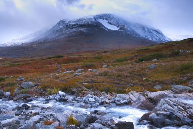
Lenticular clouds catch the last sunlight. These mountain-top clouds apparently form as the air cools down below the dew point and condenses. Pilots avoid them because they cause turbulence, while gliders seek them out to take advantage of the rising air. (I learned a New Thing)
Sunset at another beautiful tent pitch.
Trekking a valley between steep mountains.
On my way towards the highest pass of the route.
A stunning display of northern lights that went on for hours. I've seen this extraordinary phenomenon before, but this time it was much more intense and active. The waves of light literally were all over the sky, eerily flickerering and streaking across the stars. I managed to catch a bit of reflection in the lake here. Photographed using a tripod, with an ultrawide lens set to the lowest possible apperture, manual focus to infinity, an exposure time around 8 seconds and higher ISO.
I put a colored led light inside my tent to photograph it with the northern lights. Not an original idea, but I couldn't resist - it just looks so cool.
Good decision-making includes knowing when it is time to turn back. I'm an experienced hiker, but not a rock climber by any means. I was way out of my comfort zone, alone in remote country and the climb up the highest pass of the route only got steeper and more dangerous. About 40 km into the trip I decided to quit the rest of the route. Two very kind couples from Nuuk on a day trip took me back to Nuuk with their motor boat, stopping in the middle of the fjord for some deep sea fishing. Seven large fish were pulled in within a 15-minute timespan. These cold seas are so rich, it's astounding. I love to experience these slices of local life.
Once back in the capital, I consulted my maps and made a new plan. I would take a boat taxi to Kapisillit and embark from there on a second trekking, from the village to the place where you can see the ice cap terminate into the Nuuk ice fjord (This place hasn't a name, but it's a moraine at the end of the Tasersua valley, overlooking the ice fjord and Akullersuup Sermia beyond). This second, 90km there-and-back trek was very different in character than the first. Through wide open tundra it went, scattered with glistening lakes and streams and more gently rolling hills. A kind of landscape I've come to love over the last few years. It wasn't much easier to hike than the trek out of Nuuk had been, but blessidly with less risk of falling to my death. I enjoyed the sunny, chilly weather, witnessed a second spectacular show of nothern lights, paddled my little yellow packraft along two long lakes, and was rewarded at the end of the trek with a gorgeous view over the huge Akullersuup glacier calving into the iceberg-filled fjord. And all the time I was alone with the shy wild reindeers, the autumn colors and the cold, pure air. I did my fair share of swearing at the relentless bushwacking but was ultimately, utterly content. On my way back to Kapisillit, snow started to fall.
Sunrise at the lakeshore. Tundra may seem harsh and barren at first glance, but there's such beauty and silence to be found here.
Paddling Qajartararsuaq, about 6 km, in my bright yellow Anfibio packraft.
A complete halo around the sun. Very cool.
I was treated to the northern lights once again.
This wave of light went full circle. My lens was just wide enough to capture it.
A final climb over a low but steep pass brought me to the very edge of the habitable coast area. Looking out over moraine towards the Nuuk icefjord. You can just see the inland ice cap beyond.
I couldn't get enough of this view of the huge Akullersuup Sermia, an arm of the ice cap, calving into the icefjord. I often try to 'layer' my photos: including a foreground, like this waterfall, often makes for a more interesting photograph than a close-up one of just the glacier.
Finding my way back to Kapisillit through shrubbery, while sourrounded by snow showers.
Mid-September; the first snow of the long winter ahead.
Back in Kapisillit. The houses of the village looked very small beneath those snow-dusted mountains.
A lonely red house against a snowy mountain backdrop. Always cool.
Exploring Nuuk
From Kapisillit I once again hich-hiked (hich-boated?) a boat ride back to Nuuk, this time with a lovely small family with some young kids. I had a few days more to explore the city and its direct surroundings.
Nuuk is uniquely Greenlandic. It has that 'barely clinging onto the rough rocky coast' look to it I've seen nowhere else. Platforms have to be build to allow for house contruction. Colorful wooden houses mingle with appartment blocks and industrial buildings, and there are several harbours. Asphalt roads wind through the city, criss-crossed by elephant trails and long wooden stairs that allow the many pedestrians to cut through. In contrast to Sisimiut and Illulisat though, Nuuk has more of a real city feel to it. It even has a quite lively city center with shops, cafés, restaurants and bus stops. Aimlessly wandering the many neighbourhoods and bays and stairs of Nuuk is good fun, as is enjoying delicacies like shrimp sandwitches and cake after so long eating only trail food. The Greenland National museum is also worth a few hours of your time, with its great collection of ancient and more modern artifacts, and insights into Greenlandic history and culture. On my last day I did a day hike around the small mountain Quassussuaq, carefully navigating some steep, snow-covered rocky slopes. Even this day hike wasn't easy (is anything in this part of Greenland?), but it's very much worth it.
A neat row of colorful houses I found in Nuuk.
Twilight at one of Nuuk's harbours. An exposure time of 30 seconds gave nice, smooth reflections and light trails from the few passing cars.
A day hike around Quassussuaq, saying goodbuy to beautiful, rugged Greenland.
Want to do this trek yourself? Some advice (and warnings) - This route is indicated as having a difficulty level of up to T5 as defined by the Swiss Alpine Club hiking scale, having sections of 'easy climbing, but exposed', meaning you'll need hands and feet and one slip can result in a deadly fall. Add a large, heavy backpack and wet or even icy rocks, and the easy also isn't easy anymore. I would only advice the Nuuk - Qooqqut part of the route to those confident in scrambling/basic alpine climbing and in possesion of iron nerves. I heard the Qooqqut-Kapisillit part is easier and more frequented, though looking at the map it also has a few sketchy passages. The trekking from Kapisillit to the ice cap I did is also entirely off-trail, but much more managable. You really want a packraft to paddle the length of Tasersua, though. The hillsides on both sides of the lake had some very rocky and steep slopes. - The whole route goes through rough, remote country. There's a good chance you won't meet other hikers and there isn't phone reception anywhere, so definitely take something to call in last-emergency aid. I've got a personal locator beacon (PLB), but a satellite phone is also an option. The Greenlanders that gave me a boat ride back to Nuuk also recommended to bring flares to let a rescue helicopter know your location and a radio to be able to communicate with any boat you see in the fjords. The end of the Kobbefjord is regulary frequented by people from Nuuk making a day trip by boat, so that's a possible back-out option. The same is true for Qooqqut. - Plan in a lot of time. Hiking in this terrain is slow-going; 10 km a day is already quite an archievement. - Bring microspikes. They made hiking steep sections in snow much easier and safer. - Packrafting the fjords is possible, but far from ideal (at least in my fairly minimalist packraft). The wind is often strong, waves can be high and it can go from windstill to near-gale within 10 minutes. Good landing places also are rare. Don't expect to find any sandy beaches - if you're lucky you can find a very occasional pebble beach or some flat rock slabs, the rest of the coast is either boulders or cliffs. I paddled one section of the Kobbefjord (bypassing a huge boulder field) but used my packraft further only on lakes. - September is perfect for beautiful autumn colors, a delightful lack of musquitos and nothern lights. If you want to do the Nuuk - Qooqqut section though, July or August is probably better. It was already difficult enough without snow or ice, which is a likely possibility in September. - I used the Nuuk and Nuuk-Austmannadalen hiking maps from Harvey. They're beautiful maps, but don't trust the maps description on there being sections of this route with 'somewhat of a beaten trail'. Except on the first few km's out of Nuuk, there isn't a trail. Nowhere.
Let me know if you have any questions or would like more specific information about my trekking route!


Comments
Post a Comment